After setting up camp in Red Creek campground and having a couple of hot dogs cooked over the Coleman stove, we were off for a quick hike. The hike I planned was to a rock formation I spotted a month earlier when I hiked to the Lion's Head formation. You can see the rock formation in the distance, directly across Red Creek valley from Lion's Head in this photo from my July hike.
 It was a late start (6:20 PM) but the hike was ~3 miles total - out the Wildlife trail to Rohrbaugh trail, to the overlook and back. Just in case we didn't make it out before dark, we each loaded up headlamps and I carried a larger Maglite in my pack.
This would be Ross' first hike into the sods and he wanted to be prepared: hydration bladder, fanny pack, walking stick (a souvenir from the Smokies), binoculars, head band, and three lights.
 We didn't make very good time on the way in, lots of question to answer! What's this? What's that? Are we almost there?
It took almost 90 minutes to travel the first 1.5 miles to the overlook. Ross broke out the binoculars to check out the Lion's Head.
 Again, the haze and overcast skies made the view of Lion's Head pretty poor, but we posed for father/son photo regardless.
With about an hour left before dark, we headed back for the trailhead. In order to make better time, I ended up with the walking stick and the fanny pack. We didn't make it out before it got dark in the dense cover and we put the lights to good use. We made much better time on the way out, covering the 1.5 miles in almost an hour.
Once back at camp, we had a nice (and quick) campfire before hitting the sack.
I woke Ross up well before daylight, in order for him to see his first (?) sunrise. We hiked out on the North Fork Mountain overlook in the pitch dark. Unfortunately, as the sun started to rise, I found we were in the wrong location to get a good view of the sunrise. We changed location and we were able to watch a very nice sunrise.


 Following the sunrise and a quick jaunt around Bear Rocks, it was back to pack up camp and head for our next destination. Following an unplanned tour of the back roads of Hardy & Hampshire counties, I finally located the not so welled marked wildlife management area.
 We also discovered what the numerous small fish were. Apparently the brookie YOY are doing very well.

 Following this last and largest fish of the day, we decided to head back out and up the mountain. On the way back to the base of the trail we flushed a woodcock, followed him to where he landed, and flushed him again so Ross could get a quick look at him - his first woodcock.
 Once the GPS indicated 200 yards remaining, he decided he wanted to race to the top. Ross passed me but when he stopped to catch his breath, I passed him and I reminded him of the tale of the tortoise and the hair. The tortoise won this race to the top but I was more than impressed him his stamina and determination.
 We returned to camp to recover and grab a bite to eat - Spaghetti O's and peanut butter crackers. I was ready to rest but Ross was ready to fish, although he wasn't interested in hiking back down to the brookie stream. I knew the South Branch of the Potomac was nearby and this meant smallmouth. The only issue was I didn't have anything bigger than a 2wt.
 The water was crystal-clear and it was easy to see there were smallmouth everywhere. The question was: would they take a hopper pattern?
 Ross started out wading in his shirt and sandals but decided the water felt too good to not swim, so he ended up in shorts only.
 The little 10"-12" smallmouth, they were plentiful! Landing them on a 2 wt was a lot of fun too!
 We finally called it a day on the water and a grand day it was - brookies in the morning and smallmouth in the evening. To top it off we saw Ross' first black bear as we were driving back up the mountain to camp.
 On the way back to the vehicle we spotted one of the largest black bear tracks I have ever seen.
 We made it up and back in 2.5 hours and Ross again made the entire hike without a single complaint - just many more questions.


 As we worked our way downstream through this very rugged section of stream, I learned why the ground seemed to disappear in the rhododendron thicket - there was no ground! It's a good thing I decided not to push through the thicket, had I done so it would have been a real bad day.
 After working our way past this obstacle we found a route we could work our way back up to the trail. It was nearly straight up but at least we weren't fighting the rhododendron.
 Once at the end of the pine grove we were looking for a small trail out to the rock outcroppings that would contain Lion's Head. The trail was easy enough to find and the view was simply amazing.

 I had one more spot I wanted to visit before we headed toward Seneca Rocks and Spruce Knob. There is an overlook with a great view of North Fork Mountain and the Chimney Rocks formation.
 From the top of Dolly Sods it was down to the Potomac watershed and one of the most scenic drives in the state - Route 28.
  Following a quick stop at the Seneca Rocks Visitors Center, it was on to Spruce Knob where we would set up camp for the night and meet another friend for Sunday's journey.
 From the overlook we made it to the campground, pitched the tents, and had dinner. These would be firsts for my young friend: first night in a tent and first freeze-dried meal.
 I was anxious to hit this trail, as it would be the personal completion of Seneca Creek. I had traveled Seneca from the mouth to just below Judy Springs and this section would complete the "puzzle" which is the entire Seneca Creek watershed.
 The next stop on our journey was the upper falls of Seneca just above the junction with Horton Trail. As an indication of how low the water was, this set of falls normally has two major streams over the falls.
 Once at the deepest point in our adventure, we stopped for some photos and a quick bite to eat. The next task was to put my young friend on the first fish of his life - he had never been fishing before. With the low water I had my work cut out for us. It was difficult to put a first-time fisherman on fish with the low water and trying to do it with a fly rod compounded the difficulty.
 We continued to make our way back upstream toward Judy Springs, hoping to put him on a fish but with the low water it just didn't happen. At least he can't say he has "never been fishing" now.
 The hike out was uphill the entire way but the uphill grade was not noticeable and the trail was in much better shape than the day prior - or at least not as rugged. The total distance for this day when we returned to the trailhead? A little over ten miles.
 I think Almost Heaven West Virginia showed itself very well for our visitor!
 Shortly after, I caught a second. A little bigger - things were looking good:
 That second brookie is a typical average fish in almost every brookie stream I have fished in West Virginia, but at the risk of getting ahead of myself this would not be the case today. The next flat pool produced this guy:
 So it started, nearly every little pocket produced a fish and even the long slow pools produced brookies on a slow drift. I don't know if it was the overcast skies or the low 50-degree air temps, but the day was definitely one of my best (if not THE best) brookie fishing days in West Virginia.
  By this time I had easily hit double digits but my friend was still picking up a few here and there until he switched flies. I typically fish small flies for the brookies, and they produce, but when I saw what m friend had switched to I was amazed. He had switched to a very large (size 10?) grasshopper with a caddis wing and he was absolutely hammering them now.
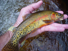
 The little palm-sized camera does take good macros:
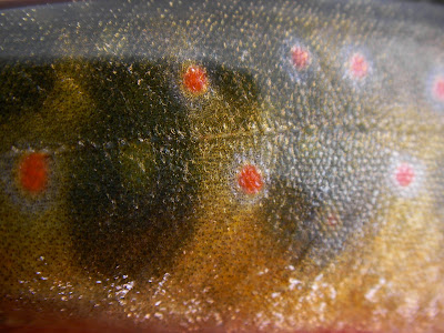 It also takes nice underwater shots too:
 And so it would continue, for over six hours we caught fish at an amazing rate. I would guess between the two of us we had to be pushing triple digits. The amazing thing was the average size. Most brookie streams I have fished have an average size of four to six inches; this stream average fish was six to eight inches with several fish over the ten-inch mark!
 The last fish of the day for my friend had a strong gold tint to it. It's hard to tell in this photo, but you can almost see the monstrosity of the fly he was fishing.
 The other amazing feature of this stream was the resemblance (we both agreed) to Roaring River in Rocky Mountain National Park. Both streams have been absolutely scoured by floods. Minus the hardwoods you can see resemblance of the streams
 Roaring River in RMNP:
 Before we started our mile and a half hike back to the vehicle, I hit a hole where one of the feeders dumps in - for the second time. I had already caught three out of this junction pool but one more drift had a brookie come about two feet out of the water as he missed the big fly and another drift resulted in yet another eight to ten inch brookie - time to call it a day.
 With the rain continuing, I chose to leave the DSLR in the car. It's a shame because this little stream had some beautiful moss-covered rocky runs of many little brookie streams I have fished.
 We fished for a little while, just long enough to validate a healthy brook trout population - as I do with most of the streams I explore.
 I ended up stinging a couple more and picking up a total of four wild browns. These wild browns had some amazing features. The adipose fin on this one was blood red and the main rays of the caudal fin were also a brilliant red. The heavy canopy made photos with natural lights nearly impossible, so I used the built-in flash which, flooded out the colors.
 I thought I was going to strike out on the other two species, but I was able to pick up this little guy before I finished.
 I had climbed a considerable distance when I decided the scramble out would not be worth any further climbing. I did not catch the third species, the brook trout, but then again I've never had much success fishing for brookies in seriously stained water. I'll keep this stream on my list and hit it again when I can find it running clear.
 Even though we fought off rain for two days, it was a great time to be in the mountains of West Virginia. The state flower, the rhododendron was blooming everywhere.
 The blooming rhododendron was just a bonus on top of the memorable day we had on the first stream.