Once we were back on flat ground, we stopped to take a few shots of Mt. Whitney and discuss when we would return to add it to “the list”. Then, it was back to the USFS to return that dreaded 5-pound sled they call a bear canister. From Lone Pine it was north to Bishop for lunch. I’m not sure of the pizza joints name but it was one of the better pizzas I have ever had – their motto was: “we toss’em, they’re awesome”.
While in Bishop we stopped in a fly shop where the older gentleman told us the story of how some hotshot jet pilot went into Golden Trout Wilderness with a helicopter and grabbed some goldens for his hunting camp in Utah. Once Utah found out they had goldens, they started spreading them to other states in the west. The older gentleman (I’m guessing about 75-years old) said he used to spend entire summers in the GTW before it was designated wilderness. He said back then that was the only place in the world to catch goldens! I laughed and told him Nathan had just told me that exact story the day before. Turns out, that “hotshot jet pilot” was also from West Virginia and his name is Chuck Yeager….small world!
Our final destination for the evening was Yosemite National Park. This park has also been on my bucket list for quite some time and I figured I would check it off while I was in the neighborhood. It would be the only day (other than driving) that I did not have fishing on the itinerary.


 The drive across Tioga Pass Road was amazing enough, but I wanted to see Yosemite Valley and all it has to offer. The plan was to find a motel room some place near Yosemite Valley where we could shower (#2 for the road trip) and find a bed (first time on the road trip). I think this may have been the only leg on our trip where I should have planned better and didn’t, as it took nearly 40 miles of following the Merced River to find a hotel room in our price range. For $80/night we found a room in Muir Lodge with two beds and two TV channels – and they were the same channel. Most importantly, though, they had hot showers and beds!
The next morning we were again up and daylight and on the road early to beat the crowds in Yosemite Valley. Our first stop was El Capitan as the sun was just high enough to catch it with early rays.

The next stop was Vernal Falls.
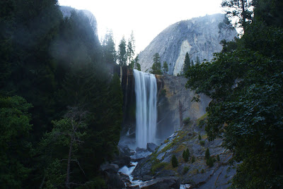 I wish I had a dollar for every time we were asked on the way down if we had already been up and back to Half-Dome. I’ve seen pictures of the conga line going up Half-Dome, and from the crowds it looked like another busy day. However, from the condition of some of the folks we passed I don’t think half of them were capable of making it.
 In preparation, and in interest of his works, I have been reading a collection of John Muir works. His presence is everywhere in the valley and I couldn’t help but wonder what this valley must have looked like before it was developed.
 The haze had moved into the valley early and the shots of Half-Dome did not turn out as well as I would have liked.
 On the way out of the valley, it was one last stop at Bridal Veil Falls. I should have stopped on the way in! By the time we made it to the undersized parking lot it was a game of musical chairs for a parking spot. I finally found a spot along the road but by the time we made it to the base of the falls the sun was at the perfect declination that you couldn’t see the top of the falls for the glare. I made one more lap around the short loop and finally got a decent shot of Bridal Veil Falls and Cathedral Rocks.

 From the valley it was back across Tioga Pass Road. Before we left, I got one last glimpse of the amazing Yosemite Valley (you can see Bridal Veil Falls in the bottom center).
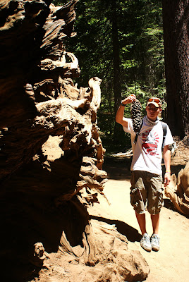
 Our first stop on Tioga Pass Road was the sequoia stand. I had never seen one and I could not believe how big they were.
 Even the pine cones were big.
 From the stand of sequoias there was only one more stop. Nathan had scoped out a small stream he wanted to fish before we left Yosemite National Park. I didn’t plan to fish; just soak my feet in the nice cold water. The first fish Nathan pulled out was a nice 10” brookie. Needless to say it didn’t take me long to string a rod up in an effort to add another state to my brook trout list.
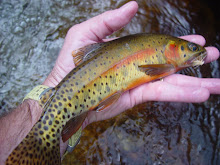
It took me a while but I finally added state number twelve to my brook trout list. In the process I caught what I called the Yosemite Slam: a rainbow trout, a brown trout, and a brook trout.
Dana Fork in Yosemite National Park.
 After completing my Yosemite Slam, it was back down to Rt 395 then north where the plan was to set up camp at the trailhead for our trip into Silver King Creek. Again, along 395 we stopped at a little road-side restaurant for a meal. This one happened to be south of Coleville and the fair was barbeque. Maybe it was the fact we had been living on college food for over a week but this was also some of the best bbq I had ever had.
With our stomachs extremely full, it was on to the trailhead where the following morning we would meet up with Dave Balducci for the hike into the native range of the Paiute cutthroat.

 The next morning we met up with Dave and completed the hike into the open water section of Silver King Creek. We fished the open end of one of the tributaries that were reported to have Paiutes, and we also fished a couple miles of Silver King proper. You won’t see any photos of Paiute cutthroat in this entry as there were none caught. We did catch MANY rainbows in the 8-10” class and they were impressive rainbows at that. I don’t know that I have ever caught so many high-flying trout. I had several of these small rainbows jump three feet out of the water before they were landed.
After going five for five on our previous native quests, we were now five for six. Nathan nicknamed the Paiutes the unicorn cutthroat…do they actually exist?
We put in about ten miles in search of the Paiute in the native watershed and came up empty-handed. What made this so easy to handle was the fact that I finally met one of the “founding fathers” of native salmonid fishing. We sat around the campfire that evening to past midnight (the latest night of the entire trip) talking about streams and fish in far away places. What a pleasure that was!
I thought we would spend the following day fishing with Dave but the fact that he had just taken his foot from a cast two weeks earlier would keep him from putting in trail time on back-to-back days. We parted ways that morning, he was headed for bigger water and we were headed for Lahontan cutthroat water.
The hike into Lahontan territory was a short one – only three miles on the Pacific Crest Trail. I couldn’t believe how much snow was still at the pass into the high meadow.
 The meadow itself seemed to be only in late spring with all of the wildflowers and it was actually the first day of August.
It didn’t take long to land my first Lahontan in California as I pulled this little guy from the first bend pool.
 We both caught several Lahontans with the largest being about 10”. The size didn’t matter, though, this was species number four for our California Heritage Trout Challenge – we were over half-way there.
I wish I had a dollar for every time we were asked on the way down if we had already been up and back to Half-Dome. I’ve seen pictures of the conga line going up Half-Dome, and from the crowds it looked like another busy day. However, from the condition of some of the folks we passed I don’t think half of them were capable of making it.Following Vernal Falls, it was off to Yosemite Village and Upper & Lower Yosemite Falls.
In preparation, and in interest of his works, I have been reading a collection of John Muir works. His presence is everywhere in the valley and I couldn’t help but wonder what this valley must have looked like before it was developed. The haze had moved into the valley early and the shots of Half-Dome did not turn out as well as I would have liked. On the way out of the valley, it was one last stop at Bridal Veil Falls. I should have stopped on the way in! By the time we made it to the undersized parking lot it was a game of musical chairs for a parking spot. I finally found a spot along the road but by the time we made it to the base of the falls the sun was at the perfect declination that you couldn’t see the top of the falls for the glare. I made one more lap around the short loop and finally got a decent shot of Bridal Veil Falls and Cathedral Rocks. From the valley it was back across Tioga Pass Road. Before we left, I got one last glimpse of the amazing Yosemite Valley (you can see Bridal Veil Falls in the bottom center). Our first stop on Tioga Pass Road was the sequoia stand. I had never seen one and I could not believe how big they were. Even the pine cones were big. From the stand of sequoias there was only one more stop. Nathan had scoped out a small stream he wanted to fish before we left Yosemite National Park. I didn’t plan to fish; just soak my feet in the nice cold water. The first fish Nathan pulled out was a nice 10” brookie. Needless to say it didn’t take me long to string a rod up in an effort to add another state to my brook trout list.It took me a while but I finally added state number twelve to my brook trout list. In the process I caught what I called the Yosemite Slam: a rainbow trout, a brown trout, and a brook trout.
Dana Fork in Yosemite National Park.
After completing my Yosemite Slam, it was back down to Rt 395 then north where the plan was to set up camp at the trailhead for our trip into Silver King Creek. Again, along 395 we stopped at a little road-side restaurant for a meal. This one happened to be south of Coleville and the fair was barbeque. Maybe it was the fact we had been living on college food for over a week but this was also some of the best bbq I had ever had.With our stomachs extremely full, it was on to the trailhead where the following morning we would meet up with Dave Balducci for the hike into the native range of the Paiute cutthroat.
The next morning we met up with Dave and completed the hike into the open water section of Silver King Creek. We fished the open end of one of the tributaries that were reported to have Paiutes, and we also fished a couple miles of Silver King proper. You won’t see any photos of Paiute cutthroat in this entry as there were none caught. We did catch MANY rainbows in the 8-10” class and they were impressive rainbows at that. I don’t know that I have ever caught so many high-flying trout. I had several of these small rainbows jump three feet out of the water before they were landed.After going five for five on our previous native quests, we were now five for six. Nathan nicknamed the Paiutes the unicorn cutthroat…do they actually exist?
We put in about ten miles in search of the Paiute in the native watershed and came up empty-handed. What made this so easy to handle was the fact that I finally met one of the “founding fathers” of native salmonid fishing. We sat around the campfire that evening to past midnight (the latest night of the entire trip) talking about streams and fish in far away places. What a pleasure that was!
I thought we would spend the following day fishing with Dave but the fact that he had just taken his foot from a cast two weeks earlier would keep him from putting in trail time on back-to-back days. We parted ways that morning, he was headed for bigger water and we were headed for Lahontan cutthroat water.
The hike into Lahontan territory was a short one – only three miles on the Pacific Crest Trail. I couldn’t believe how much snow was still at the pass into the high meadow.
The meadow itself seemed to be only in late spring with all of the wildflowers and it was actually the first day of August.It didn’t take long to land my first Lahontan in California as I pulled this little guy from the first bend pool.
We both caught several Lahontans with the largest being about 10”. The size didn’t matter, though, this was species number four for our California Heritage Trout Challenge – we were over half-way there. 
 The hike out seemed short, maybe because the three miles was the shortest of our hikes, maybe it was because it was our last hike of the trip, or maybe because it was the beauty of the high meadow trail.
 From this trailhead it was west to Sacramento then north to the shadows of Mt. Shasta. I’m just glad we weren’t staying in Lake Tahoe that weekend. We were going west but the traffic going east was bumper-to-bumper for over thirty miles!
Next would be our final leg in California, the northern redbands.
Chris

 A short drive on up the road and we were on the stream of our next species, the Little Kern Golden trout. I took the first hole, a culvert hole just below the road and I had me next species, the Little Kern Golden (Onchorhynchus mykiss whitei):


 Being a few yards from the campground, these guys obviously see some pressure, as they were very skittish. I did manage to pick up five or six of these little guys, though.


 Once camp was set up, it was time to hit the creek in search of species number three of the CHTC. It didn't take long to add the California Golden trout (Oncorhynchus mykiss aguabonita) as the third species in the challenge - first pool.


 After catching goldens on nearly every cast, it was time for lunch and a nap. On the way back to the creek, after our break, we started checking out the small trickles that feed Golden Trout Creek - there are goldens in there too!


 They are a beautiful little fish in a very rugged landscape. However, they are thriving in this rugged area! My partner and I probably caught 50 fish each in the three hours we fished, including a Gila double.

 It was hard not to tie on a woolybugger and dredge it through the pools. This method produced my largest gila of the day.
 I didn't pick up any Apache trout of size but I did catch this little guy that appeared to have eaten something his own size - his stomach was quite large.
 Unlike me, my partner for the trip, Nathan landed a decent Apache at the entrance to the tree line.
 From this stream it was north to I-40, then west into California and the southern Sierras, where we would attempt to complete the California Heritage Trout Challenge.