The main reason for my trip to California this year was to climb Mt. Whitney on my 45th birthday. I did and you can find that report at this link: Mt. Whitney.
My secondary goal was to add the elusive Paiute cutthroat to my personal life list - I did that too!
While I was filling in the time between those two objectives, I made a couple of trips into the Golden Trout Wilderness.
The first short trip occurred when I came down out of the Schulman Grove of bristlecone pines to check on my Mt. Whitney permit at the United States Forest Service headquarters in Lone Pine, California. I was a two days early to pick up my permit but when you look out the west end of the visitor's center and see this...

...the wicked set of switchbacks up and into Golden Trout Wilderness, it's tough to not make a quick trip!
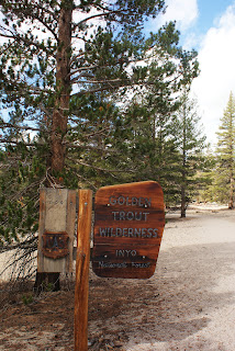
So, after a quick (white knuckle) drive up the switchbacks I found myself back in Cottonwood Meadows and the eastern trailheads of the Golden Trout Wilderness. I made my first and only visit here when I visited in 2010 to complete the California Heritage Trout Challenge. It was good to be back!
I didn't plan to do a long hike today, simply to check out the local goldens in Cottonwood Creek. Cottonwood Creek is a non-native stream for the California golden trout, but I didn't care, I just wanted to see those beautiful salmonids again.
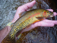
Cottonwood Creek isn't the easiest stream to fish, most likely due to the pressure it sees being right next to the trailhead campground. I did manage to pick up a couple of small goldens, but the colors here do not compare to the colors on the fish in the native waters. They were very thin too.


Shortly after starting the descent into Mulkey Meadows, I caught my first glimpse of my final destination.

Again, after what seemed like no time at all I found myself standing on the trail at the edge of Mulkey Meadows.

Considering the condition my feet were in from the previous day, the 4+ mile hike (1 hour and 45 minutes) seemed to heal me - I felt great!
I took a break and had lunch on what seemed like the only rock in the meadow. While chasing my lunch and trying to string up my rod, I couldn't help but notice how strong the wind was.
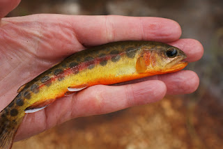
After chasing down all of my lunch wrappers and getting the rod strung up, I was headed for the water. The fish seemed to be much more easily spooked than what I remembered from Golden Trout Creek. Regardless of the wind and the spooky fish, I soon had my first California golden trout from the South Fork of the Kern drainage.

These little guys were much more colorful than the Cottonwood Creek goldens I had caught a couple of days earlier. As usual, pictures do not do these fish justice! No camera can capture the bright, fluorescent yellows and oranges!


My secondary goal was to add the elusive Paiute cutthroat to my personal life list - I did that too!
While I was filling in the time between those two objectives, I made a couple of trips into the Golden Trout Wilderness.
The first short trip occurred when I came down out of the Schulman Grove of bristlecone pines to check on my Mt. Whitney permit at the United States Forest Service headquarters in Lone Pine, California. I was a two days early to pick up my permit but when you look out the west end of the visitor's center and see this...

...the wicked set of switchbacks up and into Golden Trout Wilderness, it's tough to not make a quick trip!
So, after a quick (white knuckle) drive up the switchbacks I found myself back in Cottonwood Meadows and the eastern trailheads of the Golden Trout Wilderness. I made my first and only visit here when I visited in 2010 to complete the California Heritage Trout Challenge. It was good to be back!
I didn't plan to do a long hike today, simply to check out the local goldens in Cottonwood Creek. Cottonwood Creek is a non-native stream for the California golden trout, but I didn't care, I just wanted to see those beautiful salmonids again.
Cottonwood Creek isn't the easiest stream to fish, most likely due to the pressure it sees being right next to the trailhead campground. I did manage to pick up a couple of small goldens, but the colors here do not compare to the colors on the fish in the native waters. They were very thin too.


After landing a few more goldens, I satisfied my urgent need to see these little guys again, so I packed up my gear and headed north to search for my white whale - the Paiute cutthroat.
I successfully added the Paiute cutthroat to my list but it was one of the most brutal hikes I have ever done to add a species! I had planned to add another 14,000' peak (White Mountain Peak) to my list after the Paiutes but I was in no condition to do 14 miles on this day. Instead, I drove back to the Golden Trout Wilderness trailhead with plans to do a slightly shorter hike.
Instead of going up and over Cottonwood Pass, I would make the hike up and over Trail Pass - a much shorter route into the native waters of the California golden trout. The destination would be Mulkey Creek in Mulkey Meadows and the California golden trout of the South Fork of the Kern drainage.
Just a short distance from the trailhead, the trail splits - right to Cottonwood Pass and left to Trail Pass.

Even though I was still struggling from the brutal hike a day earlier, in what felt like no time at all I found myself standing at the top of Trail Pass looking into the native drainage of the California golden trout.

Shortly after starting the descent into Mulkey Meadows, I caught my first glimpse of my final destination.

Again, after what seemed like no time at all I found myself standing on the trail at the edge of Mulkey Meadows.

Considering the condition my feet were in from the previous day, the 4+ mile hike (1 hour and 45 minutes) seemed to heal me - I felt great!
I took a break and had lunch on what seemed like the only rock in the meadow. While chasing my lunch and trying to string up my rod, I couldn't help but notice how strong the wind was.
After chasing down all of my lunch wrappers and getting the rod strung up, I was headed for the water. The fish seemed to be much more easily spooked than what I remembered from Golden Trout Creek. Regardless of the wind and the spooky fish, I soon had my first California golden trout from the South Fork of the Kern drainage.

These little guys were much more colorful than the Cottonwood Creek goldens I had caught a couple of days earlier. As usual, pictures do not do these fish justice! No camera can capture the bright, fluorescent yellows and oranges!
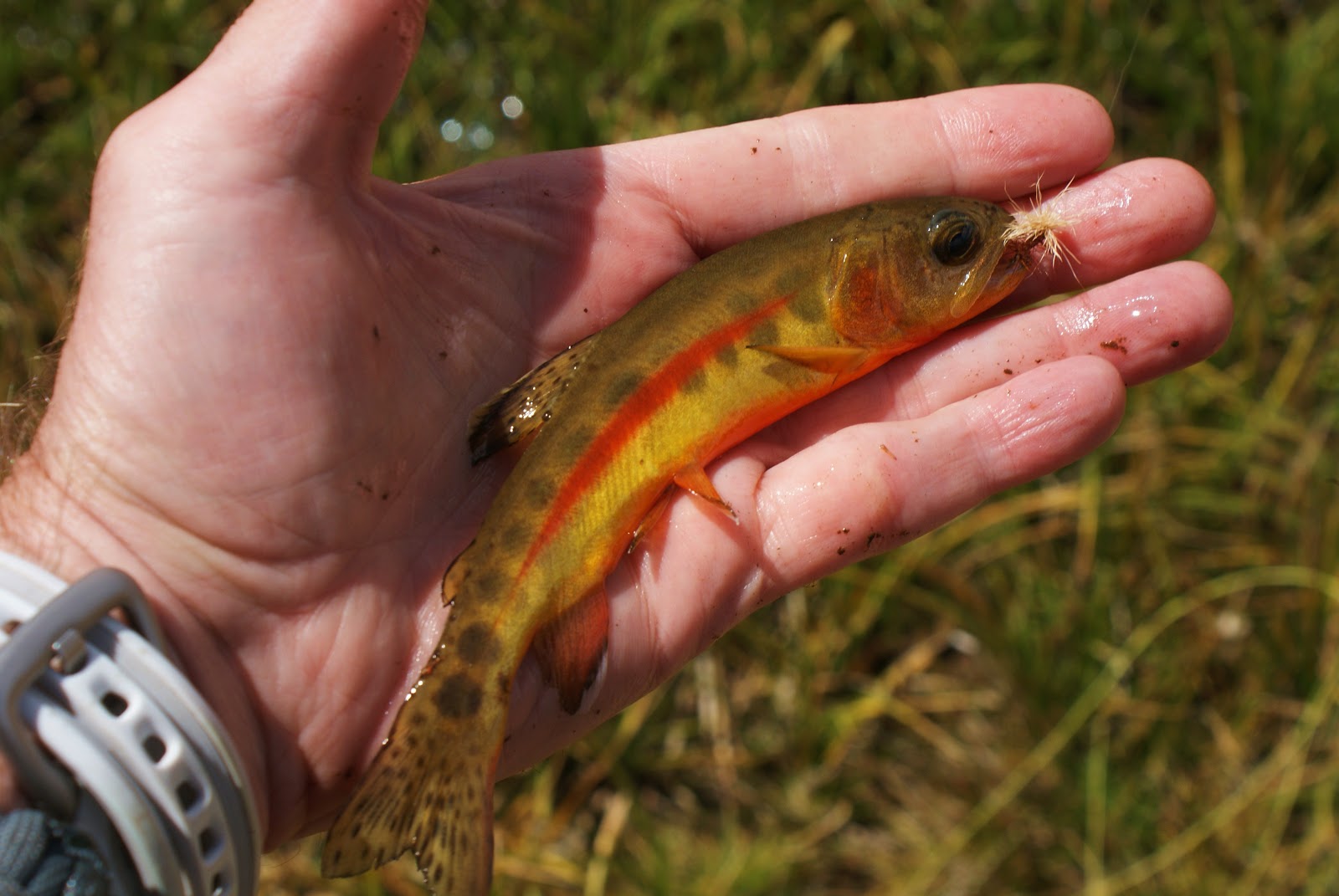

One difference I did notice between the Mulkey Creek (South Fork of the Kern drainage) and the Golden Trout Creek (Kern River drainage), was the blood red lateral stripe. These fish were absolutely beautiful!


I continued to "fish" through the wind. I was glad I brought my Sage 000wt versus my bamboo, I don't know that I could have loaded the bamboo rod in that wind. Between the wind and the narrow pocket of a stream, about one out of every five casts hit the water. You can see in the next photo what I had to hit in the wind.

The forecast was for 0% chance of rain but the wind was blowing in some dark clouds. I didn't want to get caught in a thunderstorm in a high, open meadow or even the hike back over the pass. I caught a few more small goldens then packed up my gear for the hike out.
It was nice to add the California golden trout from a new watershed to my life list - one of these days I will make it all the way into Volcano Creek!
On weary legs and beat up feet, I made the 4+ mile hike up and over Trail Pass in 1 hour and 45 minutes again. I didn't want to do a 14-mile hike this day but nine miles felt pretty good for a day hike.
One last photo, a panorama of Mulkey Meadow with my iPhone.

Chris