Sunday, September 16, 2012

California 2012 - My "White Whale"

It's been a while since I have added a blog entry. There is a very good reason for that - I haven't been fishing since my Brookiebum trip to Shenandoah National Park in June.

After I hiked my first 14er for my 40th birthday in 2007, I had been dreaming of the highest 14er in the lower 48 for my 45th. This trip to California was to climb Mt. Whitney (14,508 feet) on my 45th birthday but I figured, I'm here, I might as well fish.

I made a trip to California in 2010 to (successfully) complete  the California Heritage Trout Challenge. The only salmonid I struck out on in California was the Paiute cutthroat when I went into the Silver King Creek watershed. After the California golden trout, this was the species I most wanted to catch. I caught several beautiful, invasive rainbow trout in Silver King but I was unable to add the fish I most wanted to catch. I remember when I left California I was extremely disappointed because I didn't know if I would ever make a return trip.

When I won the Mt. Whitney lottery earlier this year, the first day trip to plan was to catch the Paiute cutthroat. This time I would take the chance out of it and hike into a stream I new contained the elusive Paiute. It is a stream outside of their native watershed but I knew this stream contained only Paiute cutthroat.

So the day came and I found myself in the campground at Devil's Postpile National Monument. Working on only three hours of sleep from the drive from Las Vegas, I got a late start on the trail - an hour later than I planned. The hike would be seven miles in on trail, then another 1+ miles of off-trail bushwhacking. An early start was much needed.

After crossing the Middle Fork of the San Joaquin, it was a short climb to the top of the first ridge. While climbing, I crossed the John Muir Trail...


...before entrering the Ansel Adams Wilderness.


It was obvious this area had previously been hit with forest fires but, this June, it wa also hit with a major wind storm. There were downed trees the entire length of the seven miles of trail. The United States Forest Service personnel had done an outstanding job clearing miles of trails! These were not small trees they had to clear, some were four or five feet in diameter!
 
Regardless, the trail was in excellent shape and the views of this rugged area were amazing.


After crossing the first (low) ridge, I crossed a stream then sarted a nearly two mile climb to the top of the second ridge. The effective use of switchbacks made this climb much easier than it would have been otherwise.
 
After descending from the pass, I started looking for my first off-trail GPS waypoint. After seven miles (2.5 hours of hiking) it was time to leave the trail. Solo, off-trail hiking in a rugged wilderness is not something I was too keen about doing but I was prepared. I had my GPS (with SPOT communicator), extra batteries, water filter, head lamp, and plenty of food.
 
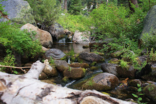
The next mile (plus) of hiking was a simple matter of following the GPS waypoints into the mini-canyon section of this stream. It was a fairly uneventful descent until I got to the second from last waypoint, at that point it was clear why my friend had marked this waypoint.
 
 
If you look closely at the photo, you can see that the next fifty feet or so was straight down over the rocky point I found myself standing on. Did I mention I was hiking solo? When I hike alone, I try not to take unneccesary risks - this one was necessary! There were Paiute cutthroat down there somewhere and I had gone too far to turn back.
 
I took my time descending this wall, being very careful with every foot placement.
 
I successfully descended this obstacle but the reality of it was I would eventually need to climb it to get out!
 
I put that thought out of my mind because I had one more waypoint to hit and that was where the Paiute cutthroat were located.
 
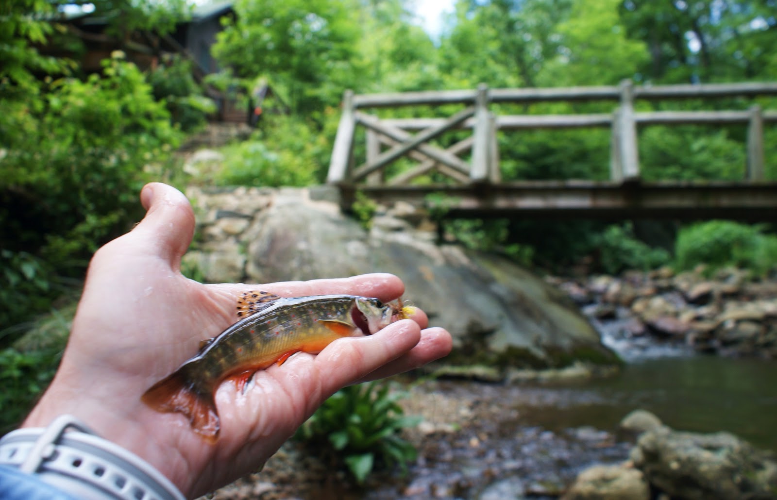
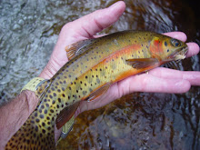
I found the last waypoint and, sure enough, I got my first look at my "white whale" - the Paiute cutthroat.


After watching the cutties swim about in every little pocket and pool, it was time to string up the rod and try to add this species to my life list.
 
With the obvious healthy population in this stream, the first pool I decided to cast a fly produced my first Paiute cutthroat.


Fishing in this stream was much like fishing in Golden Trout Creek - overpopulated. I landed 3-4 cutts in every pool or pocket of water. The population is doing great!
 
 
In the short time I fished, I landed probably close to 30 little Paiute cutthroat.


After catching my share of Paiutes, I decided to have lunch before I started the climb out. What a great place to have lunch!
 
 
With the daunting hike out ahead of me; I topped off my hydration bladder, packed my rod, and started heading up/out.
 

I climbed up the rock wall and continued the mile plus climb up to the trail. The bushwhacking was a simple matter of backtracking the GPS waypoints because (as you can see) there was NO trail.
 
 
 The first two hours of the hike out was a continuous climb. Finally I reached the pass and could see my final destination in the distance. If you can see the small granite knob about halfway up the right side of this photo, the trailhead was down the back side of that small ridge.

 
If I had remembered my spool of tippet material I would have stopped to wet a line in this stream as it was absolutely teaming with little rainbows.


It was probably for the better though as my legs were quite fatigued and I still had one more small climb to make.
 
Finally, nearing the trailhead I could see the area namesake, Devil's Postpile (just because I was there).


When I finally reached the trailhead, my feet were quite sore and my hydration bladder was empty again - I was glad to be back to the campground!
 
Of all of the native species and sub-species I have chased all over the west, this species (although not in the native watershed) has to be the most difficult to catch. A very difficult solo hike of over 16 miles, including over two miles of off-trail bushwhacking. This, and the fact it has always been one of my most sought after species, also makes this one of my most rewarding adventures.
 
Now that I have addded my "white whale" to my life list, I now have only three cutthroat species to complete the list: Coastal, Whitehorse basin, and the "Alvord".
 
Chris

Thursday, July 12, 2012

Brookiebum 2012 - Shenandoah National Park

Every year Phil and I do a multi-day backcountry adventure that we call Brookiebum. It's our annual trout bum adventure where we search for our beloved native brook trout.

Previous years have had us backpacking into the Cranberry Wilderness but this year we decided to switch it up a bit and head out of state. We debated between Smoky Mountain National Park or Shenandoah National Park. I do an annual outing every year with my son in the Smokies, so we settled on Shenandoah. The original plan was to backpack in, set up camp, and explore one watershed. I've only fished SNP one other time and my list of streams was too long to just fish one, so (again) we changed the plans and decided on a central campground where we could hit multiple streams.

Day 1
The day finally arrived, I met Phil in central West Virginia, and it was Rt. 33 all the way to Shenandoah National Park.

On the way over we stopped at a roadside brookie stream that Phil had fished a few years earlier. Once on the stream, I fished in jeans, and spooked a couple of brookies without picking one up. I took my shoes & socks off, rolled up by jeans, and moved upstream barefoot. It wasn't easy but I finally picked up one small brookie and added another West Virginia stream to my personal list.

A mile or so up the road we stopped at the spring head, only to see some of the biggest native brook trout I have seen anywhere. There they were, finning in the current, just off the edge of the underwater vegetation. I couldn't get them interested enough to even look up but it sure was nice to see something that size swimming in West Virginia waters....No photos of either the brookie I caught or the big boys swimming at the spring head - SORRY!

After this quick stop, it was on over the state line to Harrisonburg, Virginia and the gateway to Shenandoah National Park.

After FINALLY finding a campsite in the park, it was a quick dinner and a quick turn-in.

Day 2
The plan for this day was a short hike off the Blue Ridge Parkway to the Hoover Camp and the Rapidan River. From the trailhead, we were on the Appalachian Trail for about 20 yards before heading down off the mountain.


It was a short two miles to Hoover's Camp on the Rapidan, then another half-mile beyond the camp, we jumped into the famous Rapidan River. This stream has been on my list for several years!

What do you tie on when you are fishing the Rapidan River? A Mr. Rapidan, of course.


It didn't take long, the first small pool, produced my first Rapidan River brook trout.


What I failed to mention was that about thirty minutes into our hike, Phil stopped dead in his tracks, and asked me "Guess what I forgot?" He had remembered his reel but forgot his rod! The options were: Phil hike back to the top of the mountain and give up an hour of fishing or we could take turns fishing my bamboo rod. We chose not to give up fishing time and split time with my rod - Phil made the rod after all.

It didn't take long for Phil to pick up his first Rapidan brookie either.


We continued upstream taking turns on the rod. After you land a brookie, it was time to give up the rod. We were switching up quite often as the fishing in the Rapidan was outstanding and it continued to be outstanding.

On one of my rotations on the rod, I picked up the big fish of the day. This guy was a handful on the 1wt bamboo.


Having no experience on the Rapidan, I have to assume it always fishes this well, and the Mr. Rapidan got quite a workout.


I also forgot to mention I picked up a nice fly box at a fly shop in Harrisonburg - where we also picked up the Mr. Rapidan flies.


As I took my turns behind Phil, I was able to take a few shots of the beautiful Rapidan River.


We fished to the forks of Rapidan, the location of president Herbert Hoover's camp. At this junction, Mill Creek goes to the left and Laurel Creek go to the right. Above Mill Creek is the cabin that Herbert Hoover had built for the prime minister of England.

It was amazing to add another stream to my life list and in the shadows of history. If you look closely in the next photo, beyond Phil's celebration, you can make out the Prime Minister's camp.


After Phil also added this stream to his list, we decided it was lunch time and time to check out Hoover's camp.

The camp is open to visitors and there were National Park Service volunteers there to answer any questions.


I couldn't make out the maker on the bamboo rod, I wanted to think it was an original that President Hoover actually used to fish the same waters Phil and I had just fished.


Then there was Hoover's camp at the forks. The history of this location was amazing!


We could have spent hours checking out the camp, but we had new water to explore. There is nothing like catching brook trout in the shadow of greatness...add another stream to the personal list - Laurel Creek.


The tribs of Rapidan were small and heavily choked with downfall and brush. That doesn't bother me, I love extreme small stream fishing.


The water was small, the pockets were small, but the little brookies were all fat and healthy.


As with the main Rapidan, as Phil took his turn on the rod, I snapped off a few shots of this beautiful little stream.


We fished upstream to the stream crossing and this small cascade, where Phil picked up one last brook trout in the Rapidan watershed.


From here, it was about 1.5 miles (all uphill) to the trailhead. As we hiked up and out, there was one small trickle of a stream the trail crossed. I wonder if....


Yes, this stream you could step across without extending your stride contained brookies. Although this is an unnamed stream, add another one to the personal list.

Once on the Parkway, we stopped at an overlook to check in. While there Phil surprised me with an award on behalf of the West Viginia Council of Trout Unlimited - The Silver Trout Award.


That evening was a nice evening in camp, but cold for June. I wore a toboggan and a fleece jacket up until the time I crawled into my tent. The toboggan stayed on all night long...was it June or March?

Day 3
The evening before we made a decision to "run and gun" this day, as opposed to hiking off the Parkway again and hitting only one or two streams. The plan would be to drive off the east side of the Parkway and work our way south to north and hit 2-3 different watersheds.

The first watershed was the Graves Mills area and the Conway River. Once on the Conway, it was a short downstream hike to a small tributary with a great name - Devil's Ditch.

Devil's Ditch quickly produced brook trout, as Phil caught one at the trail crossing. I picked up three little brookies in no time and I added another stream to my list.


With several streams on our list that day, it was back out to the main branch of Conway - run and gun!

Phil, again, was the first to add the Conway to his list, and he did it with his own rod. The Conway was a beautiful stream that reminded me of several of my favorite streams in GSMNP. The major difference was it fished much tougher. I know I fished for about an hour before I finally picked up a camera shy brookie in the Conway.


By the time I landed that guy I was already to get off that stream so as soon as I landed it, we were done!

Next stop was another Rapidan trib, the Staunton River. To get there it was back to Graves Mills and the Rapidan River trailhead. Before making the turn up the Rapidan, we stopped at the Graves Mills post office, which was established in 1828.

Reading the Civil War it was easy to see how several of the area streams got their names. On this marker were men of the Conway, Graves, Rose families.


The history of the east side of the park is amazing, I could spend days in the area just checking out the Civil War landmarks.

Continuing with our running and gunning, the Staunton River was next. A short hike along the Rapidan, the trail split and we were following the Staunton.

It didn't take long and I added stream number three for the day to my personal list.


The Staunton was different than the other streams, in that it was a much higher gradient. There were several pools where we fished at eye level.


I picked up several brookies in the Staunton, no size, but healthy brookies. Not only were the individual brookies healthy, the population was healthy too. I saw a few very large broods of young of the year brookies.


The Mr. Rapidan worked well on this stream too!


By this time it was lunchtime again. I picked up this little box lunch in a park visitor's center/supply store. It was made by Go Picnic and it was the best box lunch I have ever eaten on the stream: multi-grain crackers, turkey pepperoni, asiago cheese, dried cranberries/pineapple, and an almond roca cookie. I'll order more of those off the internet before my next pack trip.


With a couple more watersheds on the list for the day, we decided to call it a day on the Staunton. On our last bridge crossing of the Rapidan I looked up and saw another amazing site. A bald eagle on the Rapidan, could it get any better?


Our next destination was the Rose River, so we were off to Syria, Virginia. We drove up the Rose to the park boundary and the Rose Rive trail. We hiked up the trail a half-mile or so before bushwhacking over the hill to the stream.

The stream was a beautiful tumbling stream with beautiful pools.


The fishing was not equal to the appearance of the stream. We fished for a couple of hours and we landed three between the two of us. We each caught one of these beasts!


Talk about extremes! I caught one aggressive two inch brook trout, then the only other brookie I caught was a true beast! The largest brookie of Brookiebum 2012.


That brookie would also be the last brookie of Brookiebum 2012.

We had plans to fish the Hughes, but with the trailhead parking closed, it would have been a half-mile hike up the road just to reach the trail. We both had enough miles on our legs for the day so we decided to call it a day and head back to the campground.

I finished Brookiebum 2012 by adding nine new streams to my personal life list - one in West Virginia and eight in Virginia.

It was a nice closing evening to our annual trip.We talked around the campfire about Brookiebum 2013. It's looking like Great Smoky Mountain National Park will be the destination for Brookiebum 2013, and it looks like my son Ross may be along for his first Brookiebum.

Looking forward to next year!

Chris