When I finished Part 1 of this trip entry, I had taken a rest day to prepare for the 5-day backpacking portion of my trip. In hindsight, I'm glad I took the day off but I was three days into my Colorado adventure and I had yet to touch a fish.
The second leg of my adventure started with my host, Keith, picking me up as I dropped off my rental car, then it was straight to Granby in preparation for an early morning start into the backcountry.
The plan was to hike into the west side of the Indian Peaks Wilderness, via the Roaring Fork trail. From Watanga, it would be bushwhacking over an 11,800 foot pass into Rocky Mountain National Park, then bushwhacking through Paradise Valley to the East Inlet trail for the final three nights at Lake Verna...it looked pretty straight forward on the topo maps.
This 5-day adventure would be my longest backpack trip, to date, and my pack weighed in at roughly 50 pounds. This would also be the first real test of my new Osprey Xenith 88 pack.
The initial climb (roughly 1,000 feet in the first two miles) from the trailhead was uneventful and having fresh legs was truly a blessing. The trail levelled out for the next few miles before another climb to the lake. The final climb to the lake required a few more breaks than the initial climb from the trailhead. In all, it was roughly 3,000 feet of elevation gain over the seven mile trek.
Once again, when we arrived at our destination, I was surprised to find company. These visitors, however, were not fisherman but day hikers.
As we circled the small lake and crossed the small outlet stream, it was easy to see there were plenty of fish....but would they cooperate?
Our fellow visitors didn't stick around long and after we set up camp, we had the lake to ourselves. It wasn't long after that we were into fish as the small Colorado River cutthroat were very cooperative!
At one point, I had jumped up on a small rock on the edge of the lake and caught fish on six consecutive casts. They didn't have much size but they were far more cooperative than the fish in the first lake I visited.
After catching more than my fair share from the lake, I moved over to the small outlet stream to try my luck in moving water. The results were almost equally successful.
Having worked over the moving water with more good results, I decided it was time to take in the amazing scenery and have a little midday rest.
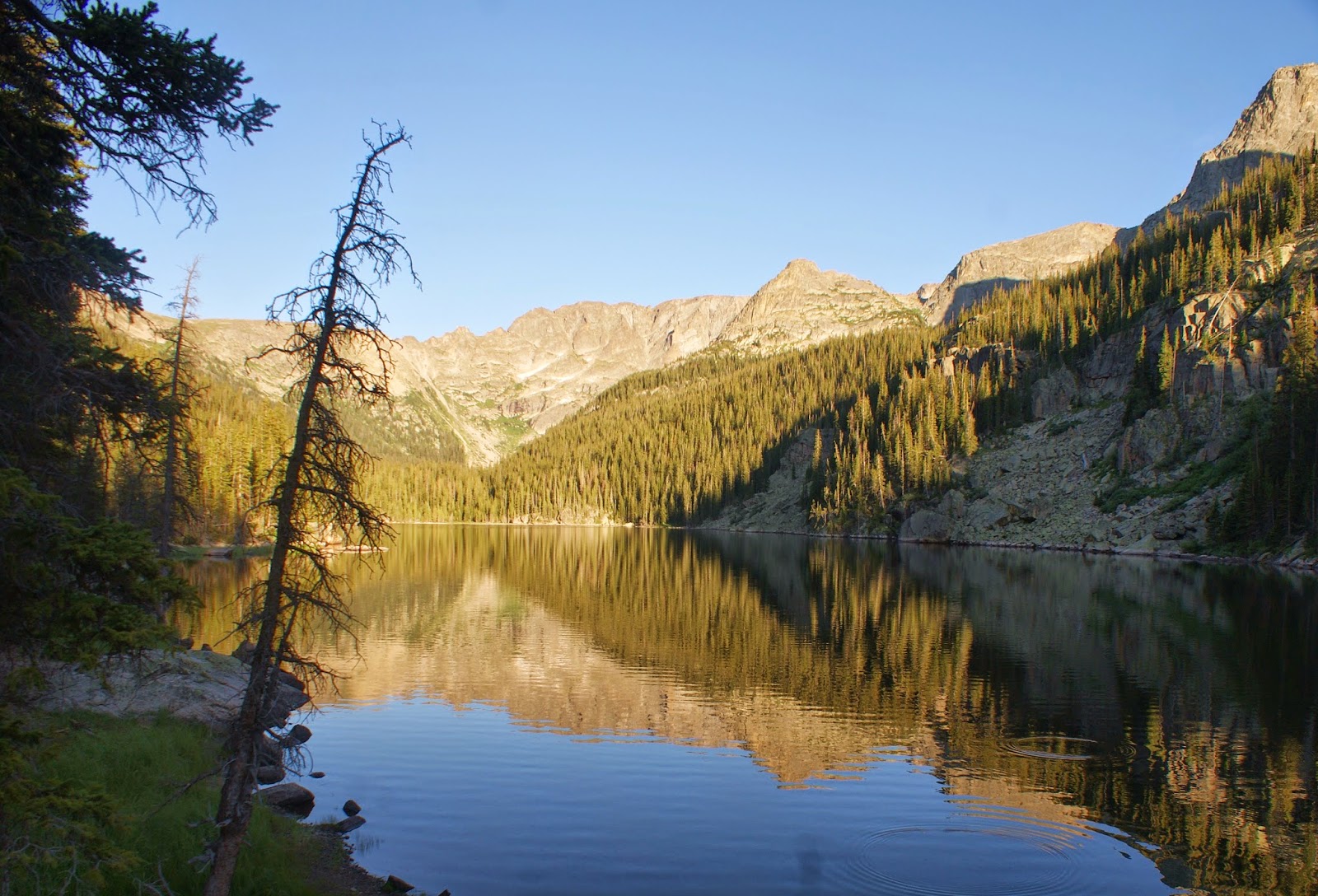
We had set up camp for the night well away from the lake and the view across the small meadow was amazing.
The lake itself was beautiful too! A good portion of the lake was lined with reeds, that (apparently) provided food and cover for the abundant population of cutthroat.
I would go back to the lake later that afternoon to catch a few more cutts but the mosquitoes and the hike up found me in my tent before the sun went down.
As normal for me when I'm in a tent, I was up at daylight. I had a quick breakfast before packing up camp in preparation for the off-trail section of the trek. The plan for the day was up and over a pass at about 11,800 feet, then down to Adams Lake in RMNP.
For perspective, check out the peak in this photo I snapped off from camp early on day 2...
The topo lists that peak at 11,721 and after two hours of climbing, we are nearly parallel (altitude) with it as we neared the top of the saddle.
Once at the top of the saddle, we dropped packs to scout out our next dilemma...How do we get down to Adams Lake?!
All I can says is, thank goodness for game trails! Keith located a game trail out of the photo to the left. It wasn't much of a game trail, it was steep with loose scree, but it was our best (and possibly only option).
At a couple of points going down, I used both trekking poles out in front of me to keep from sliding down the steep descent. My pucker factor needle was nearly pegged!
Another shot, for perspective: that is the saddle from which we crossed into RMNP, above the left snowfield and we descended between the two snow fields.
Once on "flat" ground and once my pulse had slowed down, I was able to string up a rod and start prospecting for Colorado River cutts.
The lake was beautiful and the surrounding wildflowers were in full bloom.
However, the fishing left quite a bit to desire. We circled the entire lake and did not see a single cruiser or riser; we didn't even spook a fish. That doesn't translate to a dead lake, you just couldn't prove it through us that the lake had fish in it.
By the time we had made it back to our packs, the sky had clouded up and it had started to rain. By the time we started the steep descent (bushwhacking) into Paradise Valley, it had started to rain hard. We were somewhat sheltered by the trees but the terrain was as difficult to descend as it was dropping into Adams Lake from the pass. The only difference was it wasn't loose scree this time, it was wet ground and mud...I went to my backside on a couple of occasions.
When we made it to relatively flat ground, I discovered one of my slips/slides had taken a toll on my rain cover.
Oh well, considering the remoteness of our location, I was glad it was my rain cover that had been opened up rather than one of us!
The rain eventually stopped and when we made it to the first meadow section of Paradise Valley, it was time to drop the packs and start prospecting for cutties again. This time we would be on water I'm familiar with - MOVING WATER.
It didn't take long to pick up a couple of small Colorado River cutthroat.
The fishing was good but not as good as I would have liked. I was able to pick up a few cutts through the meadow, including the largest in this section. This guy came from a nice, deep bend pool with a small log jam at the head.
That guy would be the last cutthroat from Paradise Creek for me. Shortly after I released him, I headed back down the meadow to see how my partner was doing and to see what the remainder of the day held in store for us.
We decided that somewhere up in the tress above the meadow would be a good place to set up camp for the night. Even though it was early in the afternoon, it had already been a long day. The mental stress of some of the descents had me drained and after a quick dinner, I was in my tent asleep before 6:00 PM. I didn't have any problems sleeping either!
The next day started as usual, up early and ready to hit the trail...or lack there of. Our choices were continue down Paradise Creek to the East Inlet trail or up and over Ten Lakes Park and back down to Lake Verna. The topo showed a steep descent to Lake Verna from Ten lakes and I didn't feel like another round of backside puckering, so we chose to follow Paradise Creek.
The topo with our options:
I don't have any photos from the time we broke camp until we reached our campsite at Lake Verna, and there is good reason for that.
Those final three miles to the juncture of East Inlet trail were absolute torture. It was the most physically demanding thing I have ever done in my entire life...and I've completed multiple half-marathons and climbed several 14K summits.
To begin with, the grass and bog, combined with the cool temperatures in the upper meadows created a heavy coat of "slush" on my shoes. Then there were multiple stream crossing, a bog that swallowed one of my shoes and that was the easy part.
Remember my comment about "thank goodness for game trails"? One section of Paradise Creek narrowed down to a short, steep canyon with the only passable route being on a game trail about 2-3 feet wide with a rock wall on one side and an extreme drop on the other. My "pucker factor meter" was pegged out (and then some) here! After Keith had crossed this section, I followed taking baby steps and making sure my feet and trekking poles were secure with each tiny step.
After that we still weren't done! The final quarter-mile or so was a section of blow down. We had to maneuver over, under and around pine trees that had been knocked over into the largest brush pile I have ever seen. It would have been difficult without a pack but it was very physically demanding with a full pack on. I will say that the way the new Osprey pack shifted and swiveled on it's center axis made it easier.
We finally made it to the East Inlet where we could drop packs and rest for a bit - I was whipped! Five hours to cover three miles!
The only thing remaining was another 1,000 feet of elevation gain to get to our campsite for the next three days...another 1,000 feet!
We eventually made it but I was so tired, I didn't even string up a rod after we got camp set up. The lake was beautiful and there were little brook trout rising everywhere. I just didn't have it in me, even though you can see multiple rises in this next photo.
Keith continued to fish as I spent the evening lounging on the large lakeside boulders. As he fished his way back to where I was relaxing, we were both surprised by a late evening visitor. We had a late day visit from a park ranger. I was very surprised when he slipped in behind me, I may have even jumped a little when he spoke for the first time.
It was nice to discover he was originally from West Virginia. I believe he said he was from somewhere in the northern panhandle and he graduated from WVU. Of course I always have on my "lucky" WVU ballcap when I'm in the outdoors. Also, as we spoke, we were all treated to an absolutely amazing moonrise over the jagged peaks across the lake.
After a short conversation about "home" , a quick check of permits, he was on his way down the trail and it was nearly dark. He was a at least a mile from the next camp site but I guess that's why he is a ranger.
I almost made to a total sunset this night but I was early to bed and early to rise again.
The next day we would try to rest and recover from the previous day by fishing the next two lakes up the drainage - Spirit and Fourth Lakes.
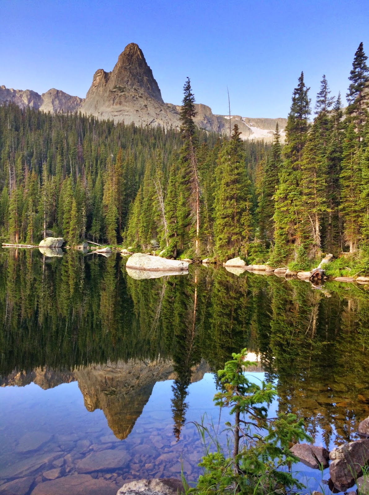
I love the early mornings with the reflections in the calm water. They make for great photos.
Lake Verna:
Spirit Lake:
And, finally, Fourth Lake:
Once we made it to the upper end of Fourth Lake, we made the decision that our legs had recovered enough to make the hike on up to Fifth Lake. The thought of the largest Colorado River cutthroat in the park was a pretty motivating factor.
Where is Fifth Lake? It's up there to the right somewhere.
The climb up wasn't that bad, of course, we didn't have on a full pack. It required a little scrambling but once we made it over the last little pitch, it opened up into a nice, open (but rugged) bowl with Fifth Lake still in the early morning shadow.
I had very high expectations for this lake! However, just as with Adams Lake, you could not prove by us that there were fish in there. We circled and fished the entire lake without a single rise, a single cruiser, and not even a spooked fish. Again, just as with Adams Lake, the scenery more than made up for the lack of fish. It was an absolutely spectacular looking lake!
After a couple of hours of prospecting, we made the decision to head back down and chase some of the numerous brook trout we saw as we passed the lakes earlier.
For perspective, that is Fourth Lake below us as we started the descent back down.
Once we made it back to Fourth Lake, we strung up the rods again and were immediately into the brookies. When you are this far into the backcountry, you expect to catch the native cutthroat, but I never complain about catching brook trout - anywhere!
Other than the California Golden trout, I think the brook trout is the most attractive of the salmonid species I have had in my hand, and these were no different.
We both caught several brookies out of both the inlet stream and the lake.
Fourth Lake brookies:
I had a nice lunch in the soft high grass along the inlet stream. I may have even dosed off for a few minutes, but then it was back to the brookies as the pace of the catching never slowed.
We decided to drop back down to Spirit Lake to try our luck with those brook trout and the result was no different.
By the time we had made it back to Spirit Lake and caught a few more brookies, we had already put in another 4-5 miles (at altitude), on a day we had planned to recover. We decided to head back to camp at this point and as we were hiking along the Lake Verna shoreline, I could start to feel the fatigue in my legs. The four days of hiking was, apparently, starting to take its toll.
I spent the evening lounging on the large boulders on Lake Verna and I set up a camera in an attempt to catch some time lapse photos of the spectacular moonrise we had the previous evening. It soon became apparent the cloudy evening was going to prevent a repeat performance, so it was another early night for me.
The last day of fishing would be doing what I know, fishing moving water. As we hiked to Fourth Lake the previous day, we noticed the stream that connected Spirit and Fourth Lakes looked very "fishy".
We would be correct! I think a single person fishing this stretch of water could easily land triple-digit brook trout!
From lake to lake we caught beautiful brook trout.
I can always tell when a trip is starting to wind down, the number of pictures start to dwindle. I probably caught over 50 brookies but the number of photos was significantly less. In addition, we stopped at the inlet of Lake Verna on the way back to camp, I landed a few more brookies but no photos. At least I caught brookies in all three lakes: Verna, Spirit, and Fourth. I'm a list guy, so I can add those to my list and move on.
The last night in camp I set up the time lapse camera again and again the moonrise did not materialize. However, we were treated to a spectacular sunset down the East Inlet drainage. No photos of that either.
The next morning was the dreaded hike out. It was all downhill but seven miles is seven miles, no matter how you measure it.
I did break out the camera for a few parting shots.
Along the trail between Lake Verna and Lone Pine Lake:
Lone Pine Lake from above:
And, finally, the last photo of my adventure and the remaining portion of the trail - through the meadow in the distance.
I had mixed feeling when we finally made it back to the trailhead. I was relieved to take that pack off my back, I felt a sense of accomplishment for what we had done, and I was disappointed that another Colorado adventure was over.
Some of the rough numbers for my 2014 Colorado Adventure : 55 miles hiked (about half of that with a full pack), 16K in total elevation gain, and two of the most physically demanding days of my entire life...the only paradise to Paradise Valley was getting back on an established trail.
Over the conversations that would follow, I agreed to return again in 2015 for another backcountry adventure, but I asked Keith to try to keep the next one "on trail". I can't wait to see what he has planned for 2015!
Chris