
 After setting up camp in Red Creek campground and having a couple of hot dogs cooked over the Coleman stove, we were off for a quick hike. The hike I planned was to a rock formation I spotted a month earlier when I hiked to the Lion's Head formation. You can see the rock formation in the distance, directly across Red Creek valley from Lion's Head in this photo from my July hike.
 It was a late start (6:20 PM) but the hike was ~3 miles total - out the Wildlife trail to Rohrbaugh trail, to the overlook and back. Just in case we didn't make it out before dark, we each loaded up headlamps and I carried a larger Maglite in my pack.
This would be Ross' first hike into the sods and he wanted to be prepared: hydration bladder, fanny pack, walking stick (a souvenir from the Smokies), binoculars, head band, and three lights.
 We didn't make very good time on the way in, lots of question to answer! What's this? What's that? Are we almost there?
It took almost 90 minutes to travel the first 1.5 miles to the overlook. Ross broke out the binoculars to check out the Lion's Head.
 Again, the haze and overcast skies made the view of Lion's Head pretty poor, but we posed for father/son photo regardless.
With about an hour left before dark, we headed back for the trailhead. In order to make better time, I ended up with the walking stick and the fanny pack. We didn't make it out before it got dark in the dense cover and we put the lights to good use. We made much better time on the way out, covering the 1.5 miles in almost an hour.
Once back at camp, we had a nice (and quick) campfire before hitting the sack.
I woke Ross up well before daylight, in order for him to see his first (?) sunrise. We hiked out on the North Fork Mountain overlook in the pitch dark. Unfortunately, as the sun started to rise, I found we were in the wrong location to get a good view of the sunrise. We changed location and we were able to watch a very nice sunrise.


 Following the sunrise and a quick jaunt around Bear Rocks, it was back to pack up camp and head for our next destination. Following an unplanned tour of the back roads of Hardy & Hampshire counties, I finally located the not so welled marked wildlife management area.
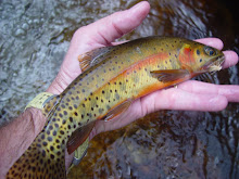
 We also discovered what the numerous small fish were. Apparently the brookie YOY are doing very well.

 Following this last and largest fish of the day, we decided to head back out and up the mountain. On the way back to the base of the trail we flushed a woodcock, followed him to where he landed, and flushed him again so Ross could get a quick look at him - his first woodcock.
 Once the GPS indicated 200 yards remaining, he decided he wanted to race to the top. Ross passed me but when he stopped to catch his breath, I passed him and I reminded him of the tale of the tortoise and the hair. The tortoise won this race to the top but I was more than impressed him his stamina and determination.
 We returned to camp to recover and grab a bite to eat - Spaghetti O's and peanut butter crackers. I was ready to rest but Ross was ready to fish, although he wasn't interested in hiking back down to the brookie stream. I knew the South Branch of the Potomac was nearby and this meant smallmouth. The only issue was I didn't have anything bigger than a 2wt.
 The water was crystal-clear and it was easy to see there were smallmouth everywhere. The question was: would they take a hopper pattern?
 Ross started out wading in his shirt and sandals but decided the water felt too good to not swim, so he ended up in shorts only.
 The little 10"-12" smallmouth, they were plentiful! Landing them on a 2 wt was a lot of fun too!
 We finally called it a day on the water and a grand day it was - brookies in the morning and smallmouth in the evening. To top it off we saw Ross' first black bear as we were driving back up the mountain to camp.
 On the way back to the vehicle we spotted one of the largest black bear tracks I have ever seen.
 We made it up and back in 2.5 hours and Ross again made the entire hike without a single complaint - just many more questions.


1 comment:
Chris,
Great blog. It's wonderful to see the father/son bonding in the beautiful West Virginia wilderness. Great story and awesome pictures. Can't wait for the next chapter.
Steve
Post a Comment