

The hike was about ten miles in length and was some of the most beautiful water I have been on anywhere in West Virginia. When the brookies return to this water, this will be another WV gem!
It was also good to see limestone fines sand dumped in the culverts on the Scenic Highway has moved more than a mile into the watershed.

Back to the stream and the beautiful water, the first stream crossing on the trail:
 The recent rains had the water up and a little off-color, not "mud" off-color but "tea-stained" off-color. The rains also made the stream crossing a little difficult for someone not wearing wading shoes (not me).
About halfway through the watershed we came to one of the most interestingly named streams anywhere!
 Hell For Certain Branch dumps into the Middle Fork of the Williams with a magnificent plunge.
 From the mouth of Beechy, it was another short mile to the lower trailhead for a total of over six hours on the trail.
 I stopped to fish a new brookie stream on the way back across the Scenic Highway, but the recent rains had the little stream nearly unfishable and I was beat from the Middle Fork hike.
 As with previous years, we would meet at Wildell - the site of an early 20th century logging community....110 million board feet!!
 Considering the weather we had a good turnout, including a couple of new guys and a couple of young children. It's always great to see the young ones getting involved in conservation, even though they don't understand the reason why we do what we do, it's good to see the outdoors.
Following the stocking we had a few hours to explore some new water with an old friend. I haven't fished with him since this stocking last year. We would be fishing another new limestone fines stream that I was made aware of the day before.
I hadn't had on waders since March but near freezing temps and a rain/snow mixture forced my hand. As much as I hate to admit it, I had to wear waders in October!
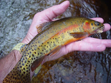
 Out of the same run came the largest fish of the day, on the dry and in beautiful spawning attire.
 I picked up a few more on the dry dropper setup, but with an hour drive back to camp and a forecast for more snow we called in an early day - almost.
 Following a long day, it was an early night with the plans for the last day still up in the air - to hike or fish?

 Once to the top from the Landis Trail, I found myself a little south of the Chimney Rock. I also discovered that snow-covered rhododendron and spike trails to overlooks are not a good combination as I found myself backtracking multiple times. Regardless of being turned around multiple times and being soaked clear through from the snow-covered jungle, the views were absolutely amazing.


 This was my last shot before heading down off the mountain. It is the storm coming across the top of Dolly Sods Wilderness Area.
 Regardless of the weather it was a wonderful day to hike. What day isn't? It was another wonderful fall (or winter?) weekend in West Virginia, and I also added two more brookie streams to my personal list - although I fished four new streams.
I had a friend tell me that now that I'm an "Ohisian", I have to get my money's worth on my trips back to West Virginia...mission accomplished!
Chris


No comments:
Post a Comment