
This trip has been on my West Virginia bucket list for quite some time. This week was initially planned to take place in the Smokies, but when that fell through, I was searching for plan B.
A few years ago I saw a report that mentioned this section of water was one of only a few in the state that has reproducing populations of all three species (brooks, browns, and rainbows).
Then, two months before this trip we had a presentation at a monthly TU chapter meeting that showed quite a bit of remediation work being done in the area. That sealed the deal! I was headed to Spruce.
The week started off with a WVCTU State Council meeting and as soon as the motion to adjourn was agreed upon, I was headed for Spruce. This solo trip mas made up of a drive to the top of Cheat Mountain and out an 11-mile (dead end) dirt road, then I backpacked six miles up the railroad tracks to my destination.
Here is a link with more information on this abandoned logging community: SPRUCE
The tourist train makes occasional stops at this location, beyond the rail station I didn't know what to expect. I was pleasantly surprised to see these markers throughout the area.


I set up camp, went to the stream to pump water for my dehydrated dinner, and that's where the adventure took a negative turn. My water filter had apparently lost a seal that allowed it to pull vacuum - no filtered water! I would have to boil all of my water and I had only packed in two fuel canisters. This was going to cut y pack trip short but I would make the best of it. It was an early evening with anticipation of a smorgasbord of wild trout to come the following day.
I woke up sometime during the night to a heavy rain pounding on the tent. The rain didn't last long but I wondered what it would do to the streams.
As is usual when I'm in a tent, when the sun is up, I'm up. I had my cup of coffee and Clif bar, while boiling water for my hydration pack. I was burning a lot of fuel!
Regardless, I packed up and headed upstream about a mile to the first tributary on my list - I had several tribs on the agenda.
The water was slightly off-color from the rain but it didn't take me long to land my first brookie.


A few years ago I saw a report that mentioned this section of water was one of only a few in the state that has reproducing populations of all three species (brooks, browns, and rainbows).
Then, two months before this trip we had a presentation at a monthly TU chapter meeting that showed quite a bit of remediation work being done in the area. That sealed the deal! I was headed to Spruce.
The week started off with a WVCTU State Council meeting and as soon as the motion to adjourn was agreed upon, I was headed for Spruce. This solo trip mas made up of a drive to the top of Cheat Mountain and out an 11-mile (dead end) dirt road, then I backpacked six miles up the railroad tracks to my destination.
Here is a link with more information on this abandoned logging community: SPRUCE
The tourist train makes occasional stops at this location, beyond the rail station I didn't know what to expect. I was pleasantly surprised to see these markers throughout the area.

This is where I chose to set up camp for the (planned) three day adventure, along the Shavers Fork of the Cheat at the end of the concrete slab that was once the rail car repair shop.

I set up camp, went to the stream to pump water for my dehydrated dinner, and that's where the adventure took a negative turn. My water filter had apparently lost a seal that allowed it to pull vacuum - no filtered water! I would have to boil all of my water and I had only packed in two fuel canisters. This was going to cut y pack trip short but I would make the best of it. It was an early evening with anticipation of a smorgasbord of wild trout to come the following day.
I woke up sometime during the night to a heavy rain pounding on the tent. The rain didn't last long but I wondered what it would do to the streams.
As is usual when I'm in a tent, when the sun is up, I'm up. I had my cup of coffee and Clif bar, while boiling water for my hydration pack. I was burning a lot of fuel!
Regardless, I packed up and headed upstream about a mile to the first tributary on my list - I had several tribs on the agenda.
The water was slightly off-color from the rain but it didn't take me long to land my first brookie.

I didn't know what this stream had in store for me as I started picking up a few more small brookies.

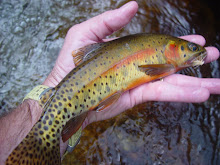
There was definitely a good brook trout population and I wasn't too surprised when I landed this little guy. I thought, at first, it was a lightly-colored brookie but when I got it to hand I realized it was a small wild brown trout.

I caught a few decent-sized brookies as I fished further upstream. This guy would be my largest brookie from trib #1.

As I pushed upstream, I came to the largest and deepest pool in this small trib and it was still stained from the rain. I made a long cast to the head and on the first drift, I hooked this next fish. I knew this wasn't a brookie as it bull-dogged and held to the bottom.
When I finally got it to hand, I had completed my slam on the very first trib of the trip - and my first slam on any stream in West Virginia!

With several other streams to explore, when I completed the slam, I headed to the next stream on my list. My next stream would be in an entirely different watershed. I crossed the low gap at the railroad switch on Cass Scenic Railroad. Down the tracks is Whitaker Station, up the tracks is Bald Knob, and the spur takes you back to Spruce.

I crossed the tacks and bushwhacked into a tributary of the Greenbrier River drainage. I was on the extreme headwaters of Leatherbark Run, which empties into the Greenbrier River at the Cass rail yard.
It was a beautiful, high-gradient section of water but I struck out on trib #2.
I returned to camp for lunch. While I was taking a break, I did a little exploration of Spruce. This is the site of the old mill, with the abutments still standing.


Of course I didn't explore the old town without my fly rod and I landed this wild rainbow while drifting a nymph against the old mill abutments.

Near the mill were the remnants of the sand and water towers for the Shay locomotions - which are still in operation today.

I dropped back into the stream and fished the short distance back to camp. I landed this little guy in the main stem (stream #3) right below my tent. Species number two in the town of Spruce.

The main stem had some unique in-stream structure in remnants from times gone by.

After lunch I headed up another section of rail, into my third watershed of the day. It was a short, two mile hike up the tracks, through the Big Notch, into the Tygart Valley watershed.

As was my adventure in Leatherbark, I struck out in the extreme headwaters of the Tygart Valley River (stream #4). It was, however, nice to see the origins of the stream that I have followed many times on my adventures in The Mon.
When I got back to camp, I boiled more water for another freeze-dried dinner. I had used up one of the two fuel canisters. Then after dinner, I hit another trib, that dumps in right above Spruce.
I fished a very short distance (stream #5)but landed a few of these little gems.

The summary for day 1: 5 streams in 3 different watersheds, brookies in 3 new streams and my first WV Slam.
It was another early evening, another night with rain, and another morning up with the sun.With only one fuel canister remaining, I made the decision to pack up camp. I hated to leave this location but when I'm solo I always err on the safe side.
You can see why I hated to leave. With the early morning mist hanging low in the valley, it was beautiful.


With those final few photos, I said goodbye to the town of Spruce. I had checked off a few more streams on my personal list and added another bucket list adventure to my list...but I will be back!
Chris


2 comments:
Nice article. This looks like an awesome way to spend a weekend. I plan on doing this next May. Were you able to drive all of the way to Beaver Creek and just walk the rest of the way?
You can drive all the way to Beaver Creek, it's 11 miles from Rt. 250 at Cheat Bridge.
Post a Comment