...and such is the life of an explorer.
While most of my brook trout exploration journeys turn up roses, sometimes they turn up very little at all.
This Labor Day adventure was a trip into the extreme headwaters of the Laurel Fork South Wilderness Area. The South Laurel Fork Wilderness is the location of the wreckage I stumbled upon while bushwhacking to the stream during a backpack fingerling stocking.

I would be traveling with my fishing partner from the
2008 Colorado Cuttslam, Phil Smith.
The hike started with a 1.6-mile hike down Camp Five Mile Trail to Laurel Fork, where we would join the Laurel Fork Trail and hike downstream to the first feeder stream. It sure didn't seem like 1.6 miles, I usually check the watch for timing but not this time. We made it to the first feeder in what seemed like thirty minutes but the journey was over two miles.
We quickly rigged up and began prospecting this nice looking meadow stream. I hooked up in the very first pool - a beautiful 2" dace! As we fished upstream I had multiple hook-ups, and all were dace. There may be brookies in the extreme headwaters of this trib, but there was nothing but silt and dace in the lower stretch. We did not even spook a brook trout.
With things not looking too promising, we turned and headed back to Laurel Fork. Once returning to Laurel we made the decision to hike further downstream in search of more promising water.
Another mile or so downstream, the stream structure did not change so we jumped in. Phil headed upstream while I went down. I spooked something in the very first pocket and missed one with a downstream drift to a root ball. I find fishing top water with a downstream drift difficult to produce a hook up. The root ball was the beginning of the remnants of an old beaver pond. The old beaver pond did not produce any more action so I turned to catch Phil.
I caught Phil just in time to see him catch a nice 10" brookie. A beautiful specimen from a very small eddy.

Little did we know that would be the only decent (and nearly only brookie, period) out of the main Laurel.
We fished good run after good run and good pool after good pool, with only several more dace brought to hand. We did find, however, a couple of clues as to the lack of brook trout in the main Laurel:
We found multiple orange seeps:

I do not claim to be any type of expert on the history of mining in West Virginia, but this type of seep is usually associated with mining. I am not aware of any mining in this area but if this is the result of mining there will be no remediation. This is the downfall of Wilderness Area designation.
Another possible (but not likely) cause for the lack of brook trout would be this happy couple:
The first thing that caught my eye was the amount of red on the larger brown. I thought we had just spotted the largest brook trout Phil and had ever seen. We gave it the old college try but he wanted nothing we had to offer. After resting the pool while we had lunch, Phil gave it another shot while I hid above the pool. That's when I noticed it wasn't a brook but a brown trout in the 14"-16" class, obviously a holdover from the annual backpack fingerling stockings.
I don't feel the presence of the browns is the reason for the lack of brookies, as I've caught browns and brookies in the same small stream in eight different streams in West Virginia. They are an invasive species but they cannot wipe out an entire population of brookies - besides they had plenty of dace in that stream to keep them fat and happy.
With hopes dashed, we decided to call it a day on Laurel and head for the trail.
Just before we hit the trail to the vehicle I "dapped" my fly at another root ball and the brook trout skunk was gone.

One brook trout twenty yards from the downstream mouth of another brook trout feeder stream would not cause me to classify this section of Laurel as brookie habitat. This section of the Laurel Fork Wilderness is very beautiful but it obviously has its issues.
I have never been to the Pacific northwest, but I would imagine it would look a lot like this area. This area had beautiful sections of conifers and ferns, with some ferns up to four feet tall.
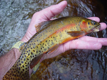
 We had spooked a brookie in the trailside feeder stream on the way in; so on the way out I hit a couple of pockets. It took no time to produce:
 Unfortunately, when things go bad even the brook trout photos turn out poorly.
Phil's GPS indicated a travel distance of seven miles, that would 2.33 miles per brook trout. That would also probably be about ten dace per mile.
We tried one more stream before heading for home, the Little River of the West Fork of the Greenbrier. It was another beautiful low gradient stream, but other than the fish I missed at the first hole, I saw only one other trout. Again, a beautiful section of stream but not very productive this day.
 It may have been the fishermen, but when you are exploring new water you can't always be successful...c'est la vie.
Chris


1 comment:
Chris,
Bummer, but beautiful! That's one of the reasons I started carrying a camera in the first place--to capture landscapes when the fishing was poor, not necessarily to take pictures of my fish. That orange seep water did not look nice. I gripe about some of the water I come across that cows have mucked up, but nothing compared to that.
-scott c
Post a Comment